
Each year during the wet season we hear news reports about landslides in America and abroad. Sometimes these events happen in unpopulated areas but unfortunately they also occur in areas where people live, causing property damage and taking lives. But what causes these events and what can be done about them? That’s what Dr. Burns, a geology professor at Portland State University is trying to answer.
Dr. Burns, whose fields of expertise cover geomorphology, engineering and environmental geology, and soils has been studying landslides for some time. One of his current projects is a collaborative study of landslides involving windblown silt (loess) in the West Hills of Portland, Oregon. According to Dr. Burns, the West Hills were “selected because of the simple geology – loess over basalt. It is easier to develop a predictive model when the geology is simple.”
Loess is a very fine windblown sand and silt that due to its molecular composition can create hills and bluffs with high vertical walls. However, loess is highly susceptible to wind and water erosion and can give way easily in landslide events. Dr. Burns’ goal is to find out exactly when these events occur by determining the moisture content of soil that will trigger a landslide, and how long it takes the loess to drain its water content and stabilize again after a major rain event.
Working with the USGS on two sites and with Stevens’ geochemist Keith Bellingham on a third, the sites have been strategically placed onto a slope in the West Hills that has experienced landslide problems in the past.
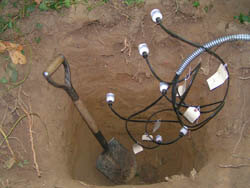
The two USGS sites, featuring wells with water level gages, have been placed into areas on one hill with less loess content in the topsoil, with one site containing mostly weathered basalt. The third site, using Stevens’ HydraProbe sensors buried at six different depths, has been placed onto an area of deeper loess deposits. The probes have been connected to a Stevens DOT Logger for data collection, and Stevens Shark wireless Bluetooth transmitter to facilitate easy data retrieval. Collected data can then be compared between the sites, helping Dr. Burns and his graduate students to determine when mass wasting events are most likely to occur.
In addition to the landslide research, Keith Bellingham is using the data collected at the HydraProbe site to study how water drains between different horizons of soil. Some soil types retain water better than others, to the extent that it can appear to throw off research data.


